


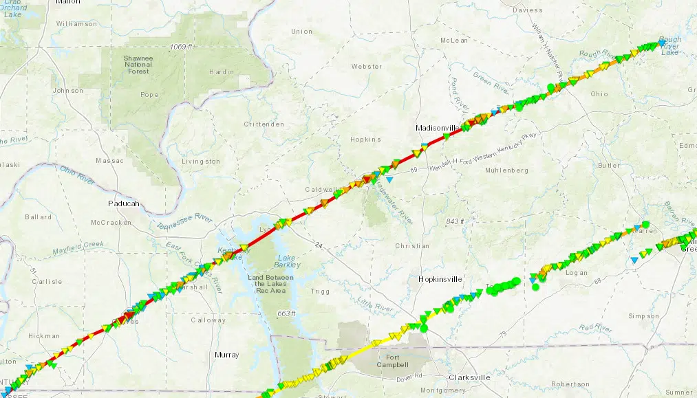
December 10, 2021 event – Preliminary Findings:
After several days of extensive surveying, the National Weather Service in
Memphis TN, Paducah KY, and Louisville KY have determined the following:
Tornado Rating: EF4
Estimated Peak Winds: 190 mph
Path Length (estimated): 165.7 miles
Maximum Path Width: A mile or more
Fatalities/Injuries: Total Unknown
Start Date: December 10, 2021 / Start Time: 8:49 pm CST
Start location: 1 mile southwest of Woodland Mills, TN
End Date: December 10, 2021 / End Time: 11:47 pm CST
End Location: 2.5 miles northeast of Falls of Rough, KY
Initial Survey Summary: Massive impacts along most of the tornado track. Worst damage
found in the following locations: Cayce, Mayfield, north of Benton, south of Princeton,
Dawson Springs, Barnsley and Bremen, and possibly others.
A historic long-track tornado entered western Kentucky from Tennessee shortly before 9:00 PM CST. The small community of Cayce, KY in Fulton County was struck directly. The tornado continued northeast through Mayfield, KY about 9:25 to 9:30 PM CST, where it produced widespread destruction. After moving through Mayfield, the tornado passed on the northwest edge of Benton around 9:45 PM and then across the Land Between the Lakes National Recreation Area. The tornado continued across the Princeton area in Caldwell County, then passed through Dawson Springs around 10:45 PM CST. The tornado crossed the Green River, which marks the eastern edge of the Paducah NWS coverage area, before reaching Beaver Dam, KY around 11:20 PM CST.
Additional details to follow as they become available.
Comments